HHT 2000 Holography Run

Map Results


We are using the LES-9 satellite, provided by the Navy and MIT Lincoln Laboratory. This satellite has a 37 GHz transmittor, which the Navy let us use for 6 hours a day. The satellite normally supports communications (most notably to the south pole research stations).

Previous holography runs are summarized for 1998, 1997 and 1995.

Here we present log entries and representative holography maps. Each map covers the range of surface errors shown (early maps are of +/- 50 microns only). The total size of the maps (in pixels) is also given. The holography maps are made by measuring the signal from LES-9 as the telescope is scanned in a raster pattern. Along a raster line the telescope is scanned at a constant rate in either the azimuth direction or the elevation direction. In principle, the direction of the raster lines should be immaterial. There was no noticeable difference between the two kinds of maps in past years. Our maps this year were made in azimuth.

There are 3 rings. The center ring has 12 panels and the outer two rings have 24 each. Each panel has several positions around the edge or in the middle where it can be adjusted. The goal is to adjust the panels so that the RMS deviations from a perfect surface are less than 15 microns.

There is a quadrapod that supports a secondary reflector. It casts a shadow along diagonal lines. We get no information about panel positions here, but they don't matter since the light that hits them strikes the quadrapod legs. The legs also produce diffraction lines parallel to them that confuse the measurement. We have blanked out the shadowed region plus about an additional foot on either side in the maps below.

The accuracy of the maps depend upon the accuracy with which one can measure the phase of the radio waves entering the feed horn of the holography receiver. The feed horn introduces phase shifts that mimic misalignments of the telescope panels. We first correct the maps for these phase shifts. An improved measurement of the phase shift due to the horn was made this summer at the Georgia Tech Research Institute. The new measurement corrected some phase errors that caused some panels to be misaligned by 5-10 microns in 1998.

Animated GIF of progress

This animated GIF shows the daily progress of the 2000 holography session. For this animation we have used the averaged azimuth scans for various dates between 09/15-10/01/2000. The scale is +/-50 microns, as it is on all plots.

RMS of Ring 1 starts at 10.9 microns, finishes at 09.4 microns

RMS of Ring 2 starts at 13.7 microns, finishes at 10.0 microns

RMS of Ring 3 starts at 30.3 microns, finishes at 19.6 microns

Overall RMS of telescope starts at 22.7 microns, finishes at 15.17 microns

We achieved our goal of 15 microns rms over the entire dish surface!

See below for the individual plots.

We present below a sample of our averaged maps to illustrate how the the holography results changed with time and panel adjustments.


Map

Log Entry

Scan

Scale +/-50 Microns
Day 6
September 16, 2000

Average of scans 5499 & 5575, 50 microns Average of two 65 by 65 maps
(5499 and 5575) taken on separate days.

RMS of ring 1 = 10.9 microns
RMS of ring 2 = 13.7 microns
RMS of ring 3 = 30.3 microns

Overall RMS of map = 22.7 microns

Average of scans
5499 & 5575
Sept 16, 2000
(65 by 65 map)
Scale +/-50 Microns
Day 6
September 19, 2000

Average of scans 5772 & 5807, 50 microns Average Map of Day 9

Sum of maps taken on same day

RMS of ring 1 = 11.8 microns
RMS of ring 2 = 13.8 microns
RMS of ring 3 = 25.2 microns

Overall RMS of map = 19.9 microns

Average Map of Day 9
5772 & 5807
Sept 19, 2000
(65 by 65 map)
Scale +/-50 Microns
September 19, 2000

Map 5807, 50 microns 
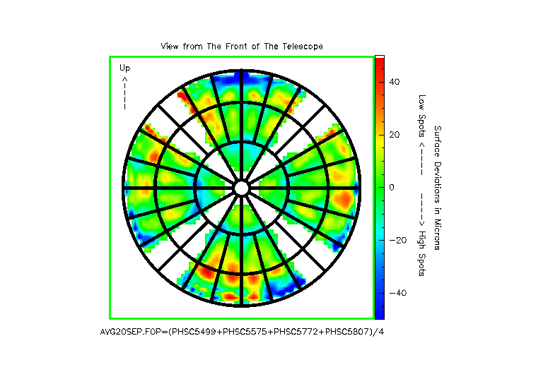
Average of scans from 3 days
5499+5575+5772+5807

This map is the pre-adjustment average

RMS of ring 1 = 10.9 microns
RMS of ring 2 = 13.7 microns
RMS of ring 3 = 26.3 microns

Overall RMS of map = 20.0 microns

Average of scans
5499+5575+5772+5807
Sept 19, 2000
(65 by 65 map)
Scale +/-50 Microns
September 20, 2000

Average of maps 6058 and 6070 
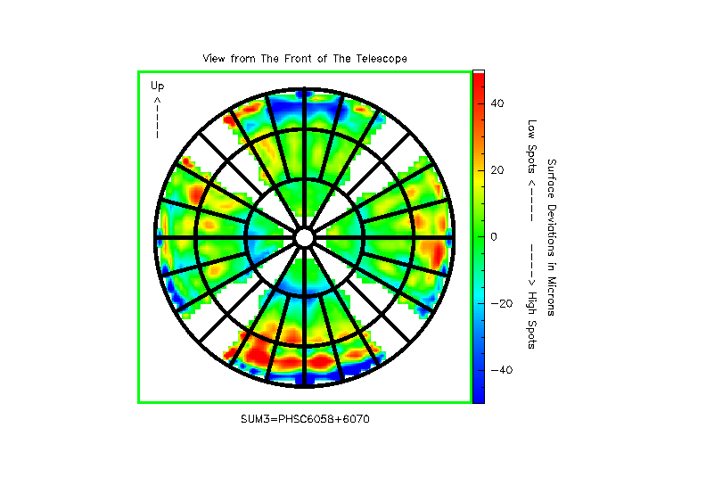
Average Map of Day 10

RMS of ring 1 = 11.5 microns
RMS of ring 2 = 12.5 microns
RMS of ring 3 = 33.8 microns

Overall RMS of map = 24.7 microns

Average of scans
6058+6070
Sept 20, 2000
(65 by 65 map)
Scale +/-50 Microns
September 25, 2000

First map after moving several panels 
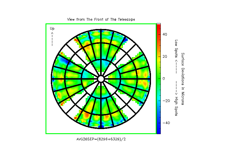
Average Map of Day 15
6296 and 6329

Panel Adjustments

Inner Ring Panels: 6,7,9,10
Middle Ring Panels: 8,13,19,20
Outer Ring Panels: 1,6,7,12,13,14,17,18,19,20,24

RMS of ring 1 = 10.6 microns
RMS of ring 2 = 10.6 microns
RMS of ring 3 = 18.9 microns
Overall RMS of map = 15.1 microns

Average of scans
6296 and 6329
Sept 25, 2000
(65 by 65 map)
Scale +/-50 Microns
September 26, 2000

average map Average Map of Day 16

Panel Adjustments

Inner Ring Panels: 1,6,9,10
Middle Ring Panels: 1,2,5,11,14,17,20,23
Outer Ring Panels: 6,7,14,20,23

RMS of Ring 1 = 10.0 microns
RMS of Ring 2 = 10.6 microns
RMS of Ring 3 = 18.5 microns

Overall RMS of map = 14.7 microns

Average of scans
6391 and 6424
Sept 26, 2000
(65 by 65 map)
Scale +/-50 Microns
September 30, 2000

Average map Average Map of Day 19+20

No panels moved.

RMS of Ring 1 = 09.4 microns
RMS of Ring 2 = 10.1 microns
RMS of Ring 3 = 19.9 microns

Overall RMS of map = 15.3 microns

Average of scans
6635+6694+6728
Sept 30, 2000
(65 by 65 map)
Scale +/-50 Microns
October 01, 2000

Average map 
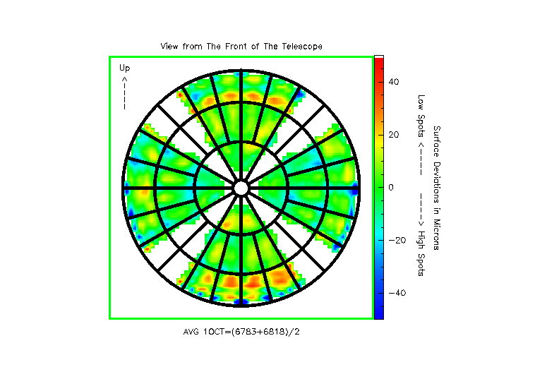
Average Map of Day 21

Outer Ring Panels: 11

RMS of Ring 1 = 09.6 microns
RMS of Ring 2 = 09.9 microns
RMS of Ring 3 = 19.5 microns

Overall RMS of map = 15.1 microns

Average of scans
6783+6818
Oct 01, 2000
(65 by 65 map)
Scale +/-50 Microns
October 01, 2000

Average map 
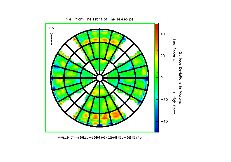
Grand Average Map of Day 20 and 21

This map is the post-adjustment average.

RMS of Ring 1 = 09.4 microns
RMS of Ring 2 = 10.0 microns
RMS of Ring 3 = 19.6 microns

Overall RMS of map = 15.2 microns

Grand Average of scans
6635+6694+6728+6783+6818
Oct 01, 2000
(65 by 65 map)


Created: 09/28/00
Last Changed: 10/03/00
contact: hbutner@as.arizona.edu